![[Currents header]](/homeart/currents_header.gif)
October 6, 1997
|
|
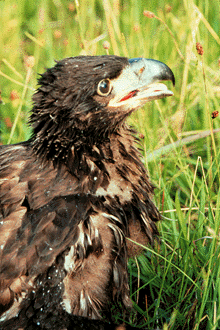
Scientists have fitted a juvenile bald eagle, like this one, with a satellite tag.
|
By Robert Irion
Along the wild rivers of Alaska and British Columbia, immature bald eagles forage for dead salmon and learn to hunt for live ones in the late summer and fall. The eagles fly north on fast migrations from their birthplaces in California and elsewhere, stunning first journeys from the nest honed by thousands of years of instinct.
At least, that's what wildlife biologists thought. Now, an information-age eagle has made that picture much more believable.
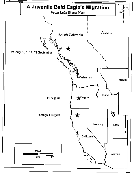
Scientists from the Santa Cruz Predatory Bird Research Group (SCPBRG) at UCSC have tracked, for the first time, a juvenile bald eagle's remarkable coming-of-age quest for food and independence. The eagle wears a tiny backpack fitted with a lightweight satellite transmitter that beeps every 10 days. Signals from the satellite, sent via e-mail to SCPBRG researchers, show that the bird flew some 900 miles in August from its nest at Lake Shasta, in northern California, to the vicinity of the Dean River in central British Columbia. The journey took less than three weeks (map of eagle's flight).
Two subsequent signals reveal that the bird is staying at the Dean River, apparently having found a rich source of food. Biologists think other young eagles venture even further north, into northern British Columbia and southeastern Alaska's spectacular fjords.
"Instinct drives these migrations," said SCPBRG researcher Grainger Hunt. "These young birds have never hunted before and have never caught anything. Yet they leave their parents behind and suddenly, they fly a thousand miles north at the end of the summer. It's very surprising."
Hunt and SCPBRG wildlife biologist Ron Jackman tagged the eagle in its nest at Lake Shasta after the bird had reached its full body size. Their work, done in collaboration with Steve Zack of the Point Reyes Bird Observatory, is part of a long-term study of bald eagles by the U.S. Forest Service, Shasta Lake Ranger District.
Over the next two years, if both eagle and satellite tag survive, the biologists will learn how long the bird remains in Canada and whether it returns to its home range for breeding. The research also paves the way for satellite tagging of more eagles, as well as falcons, seabirds, and other species of interest.
Further, Hunt said, bald eagles offer a glimpse into cycles of nature that, for the most part, remain hidden from view.
"Bald eagles are indicators of the health of the global ecosystem," Hunt said. "These telemetry studies will teach us about the eagles' food web. We may learn that the ecology of California bald eagles is tied to the health of the northern salmon runs, and thus to the abundance of plankton in the Pacific Ocean."
Hunt speculates that juvenile bald eagles start by eating carrion along the mouths and inland stretches of big rivers with huge salmon die-offs. Later, they learn how to catch live fish--a necessity before they reach breeding age.
|
|
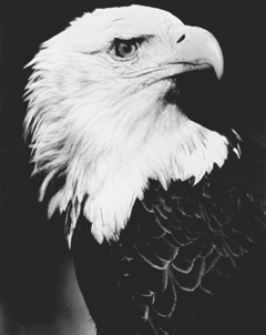
When it reaches adulthood, the tagged eagle will resemble our familiar national bird.
|
The satellite technology is a leap forward from SCPBRG's previous method of choice, radio telemetry. For instance, Hunt attempted to follow several young bald eagles northward by plane in the mid-1980s, tracking them on signals emitted by radio transmitters. He saw how quickly they flew, crossing the Canadian border from Lake Shasta in less than one week. Hunt managed to keep up with one bird as far north as Lake George, British Columbia--inland and farther north than the Dean River. But in all cases, poor weather forced him back before he learned the birds' destinations.
"This is a completely different kind of wildlife biology, like going from a typewriter to a word processor," said Brian Walton, longtime SCPBRG coordinator. "This technology will be important for tracking seabirds, which we can't follow by plane." Such birds, Walton noted, could include seabirds injured in oil spills, then cleaned and released. Satellite tags present a new way to gauge the effectiveness of those techniques.
If the eagle's transmitter works properly, the researchers will get a report on its location every 10 days for the next two years. The backpack's straps are designed to fail after that time. Hunt and Walton hope to retrieve the $3,000 transmitter after it falls off for possible future use.
SCPBRG researchers use Geographic Information Systems technology to map the bird's movements. The project is part of the group's overall management efforts for birds of prey, including the peregrine falcon in California. SCPBRG is credited with restoring the peregrine falcon to healthy breeding levels in the state throughout the 1970s and 1980s.